Material updated ↓
In September 2023, a statement widely circulated on social networks about the release of contour maps in Russia, where the continents of the Western Hemisphere are called Anglo-Saxon and Latin America. We checked if this is true.
September 23 post with photos of a collection of contour maps posted in her Telegram channel, political scientist Ekaterina Shulman (152,000 views at the time of writing this analysis). She reports that in this geography textbook for grades 10–11 published by Prosveshcheniye, North America is renamed Anglo-Saxon, and South America is renamed Latin. Also in the notebook there are allegedly “outlandish continents”: Foreign Europe and Foreign Asia. “The era of great geographical closures,” the political scientist summarized.
Photos of the cards were widely distributed on Telegram: they were published, in particular, by the channels “Live broadcast"(667,000 views), "Truthfulness" (197,000) and "Putin on Telegram"(192,000), as well as adviser to the head of the Ministry of Internal Affairs of Ukraine Anton Gerashchenko, who wrote (136,000): “They could immediately rename it “friendly America” and “unfriendly America.” Why all this dust in the eyes? News notes about the cards, from which it followed that this was an innovation in the Russian educational system, were published with reference to Shulman Astra, "New newspaper. Europe" And "Echo", and a column criticizing the term "Anglo-Saxon America" appeared in "Moskovsky Komsomolets"
First, let's define the terms. North America and South America are two of the six continents or continents that exist on earth. They determined uniquely and exclusively from the point of view of physical geography. Within one or several continents at once, scientists, using socio-economic and cultural ones in addition to physical ones, also allocate parts of the world (Europe and Asia in Eurasia), regions and subregions (Middle East, Sub-Saharan Africa), other groups of countries and territories (Balkans, Maghreb).
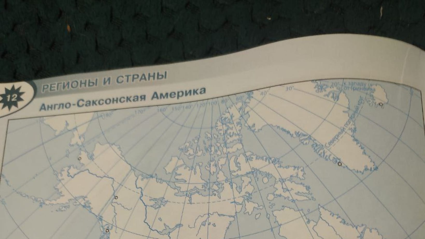
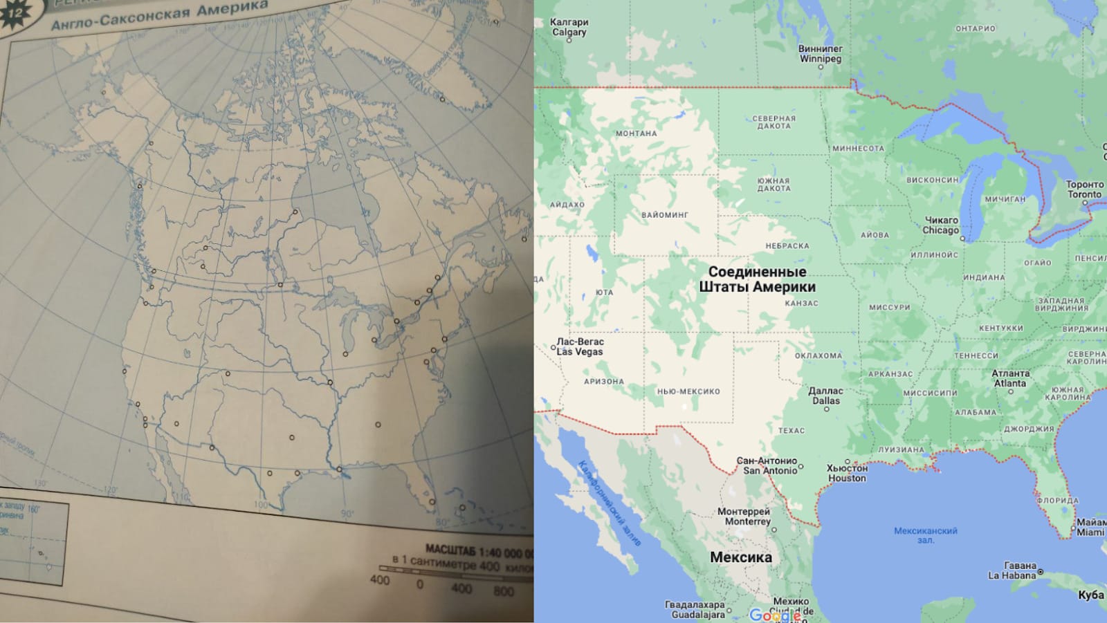
The term “Anglo-Saxon America” is not an innovation in 2023; along with the term Anglo-America, it has been used in Russian school and university textbooks and atlases on socio-economic geography for more than ten years. Mentions of Anglo-Saxon America can be found on solution sites and in plans lessons from a textbook published by the Prosveshcheniye publishing house, the maps to which became the cause for controversy. Examples of the use of the term "Anglo-America" can be discover in geographical atlases published in Russia in 2015 and even in 2013 year. At the same time, in world practice it intended to describe North American countries whose inhabitants speak English and whose traditions trace their origins to Northern Europe. Therefore, Anglo-America also includes some countries of Central and South America and the Caribbean (for example, Belize, Jamaica and Guyana), but not the French-speaking regions of Canada. Definition of "Anglo-Saxon America" in Russian occasionally used in the 19th century, in English-language literature it is practically not used.
The terms mentioned in the Russian-language sources studied by “Verified” are predominantly are used as synonyms for designations exclusively the USA and Canada, but not North America as a continent. However, in the educational materials on the Russian Electronic School portal, these two countries are still aware of socio-economic geography unite the concept of “North America” (sometimes specified as “English-speaking”).
The fact that the map from the viral photo is named so to comply with the narrow definition of Anglo-Saxon America in Russian textbooks is confirmed by its very appearance: schoolchildren are asked to mark only the territories of the United States and Canada. At the same time, on the partially depicted map of Mexico there are no city designations, and English-speaking Belize, Jamaica and Barbados are not included on it at all.
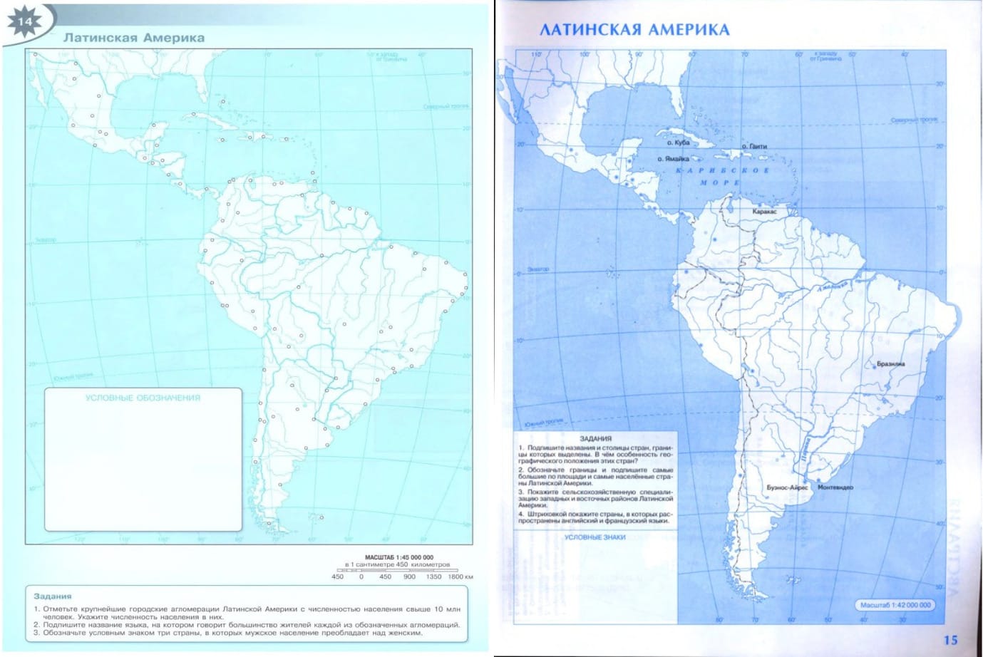
Under Latin America in Socio-Economic Geography implied countries in southern North America, the Caribbean, and South America where Romance languages (Spanish, Portuguese, or French) derived from Latin are adopted as official languages. Visit them often include also English-speaking Belize and Guyana, as well as Dutch-speaking Suriname. Judging by the designations of cities on the map in question, its authors considered Latin America to be some countries that do not belong to it, in particular the already mentioned English-speaking Jamaica and the Bahamas (the latter, for an unknown reason, were marked on the latter as part of the assignment for Anglo-Saxon America), as well as the former Netherlands Antilles (Curacao, Sint Maarten, Bonaire, St. Eustatius and Saba and Aruba), where the main language is Dutch and some of which included part of the Kingdom of the Netherlands, and part has status special communities.
However, from the point of view of physical geography, the map of Latin America depicted in the collection under discussion is correct - it covers both the South American continent, and part of the North American, and the islands of the Caribbean Sea.
We can conclude that the maps that have been distributed on social networks are made with inaccuracies in design, but there is no talk of any renaming of North and South America as continents - schoolchildren are asked to complete tasks that are related to regions formed according to cultural characteristics, and not to continents.
On one of the sites with ready-made homework, “Verified” found assignments completed using contour maps, which “Prosveshcheniye” published no later than 2021 (and on a scanned page with the table of contents, the year of development of these cards is indicated as 2017, but their names could have been changed in later reissues). Markings on these maps exactly the same as on the viral ones, and the page with the task for the USA and Canada marked, as in the analyzed images of 2023: Anglo-Saxon America. That is, this term has been used in similar educational materials for several years.
It is incorrect to consider the terms “Foreign Europe” and “Foreign Asia” as innovations in the Russian school tradition. IN textbooks And benefits, on sites with crib sheets in geography, these definitions have been used since the mid-1990s for designations a number of countries and territories of Eurasia. Both terms are ideological heritage Soviet geographical science, which appeared back in 1950s years. This is also why in some textbooks the countries of the former USSR are included in Foreign Europe and Foreign Asia, while in others they are not. After the collapse of the Soviet Union, these definitions are used mainly in the Russian school (rare mentions can also be found in Belarusian sources).
Thus, no one renamed North and South America as continents in the Russian school geography curriculum. The notebook with maps uses, although atypical for world science, definitions of Anglo-Saxon America, Foreign Europe and Foreign Asia that have existed for a relatively long time in the Russian school course on socio-economic geography. Judging by the available data, on the contour maps of the Prosveshcheniye publishing house that have been circulated on social networks, the USA and Canada are designated as Anglo-Saxon America at least from 2021.
Update September 29, 2023: The title of the material has been changed, an introductory paragraph about the difference between the concepts of “continent / mainland”, “part of the world”, etc. has been added, stylistic edits have been made. A copy of the material before changes are made is available at link.
Cover photo: page of contour maps from the Prosveshcheniye publishing house

- Anglo-America, cultural region, North America
- Why Suriname Isn’t Part of Latin America?
- Is it true that LGBT clubs have opened in Ukrainian schools?
If you find a spelling or grammatical error, please let us know by highlighting the error text and clicking Ctrl+Enter.