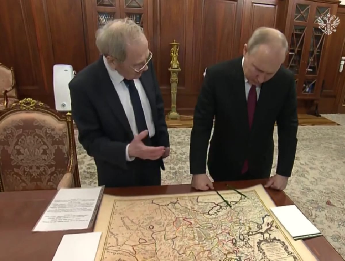
On May 23, 2023, the Chairman of the Constitutional Court of the Russian Federation, Valery Zorkin, showed the Russian President a copy of the map, on which, as he claimed, there is not even the name Ukraine. We decided to check if this is true.
At the meeting with Putin, Zorkin showed a map and explained, why he brought it to the president: “In our Constitutional Court we found a copy of a map of the 17th century, compiled under Louis XIV - that is, this is the middle, even the beginning of the second mid-17th century - compiled by the French themselves. Why did I bring her? Vladimir Vladimirovich, there is no Ukraine there. <...> There is a region in two places - the region of the Polish-Lithuanian Commonwealth and the region of Cossackia. And the great kingdom of Russia." Zorkin explained that he has a copy at his disposal, and the original is kept in Paris. Putin, in turn, agreed with Zorkin and added his own long-standing thesis that before Soviet power “there was no Ukraine in the history of mankind.”
The Chairman of the Constitutional Court did not specify what year the map was and who its author was. In the video distributed by the Kremlin press service, the entire map is shown for just a few seconds, and upside down. But by some characteristic features you can determine what kind of card it is.
In the general plan, two cartouches are clearly visible - these are ornamental shields on which accompanying text is usually written.
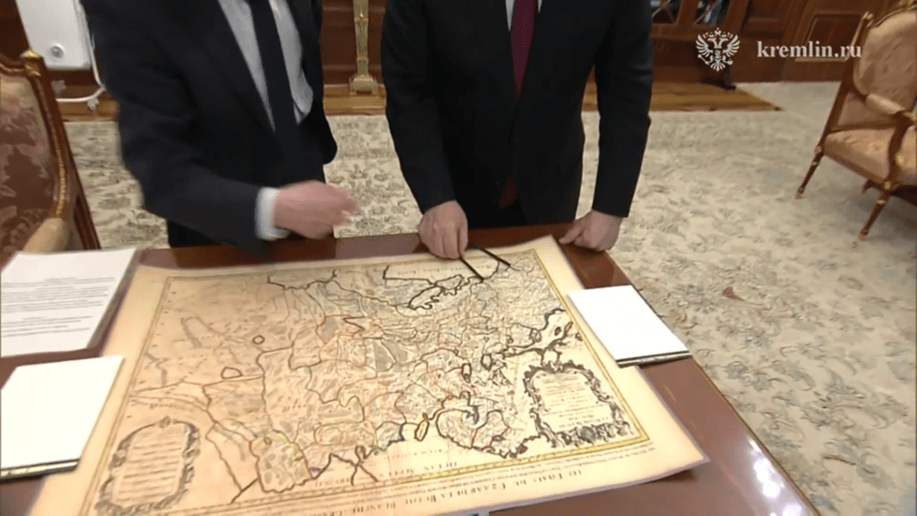
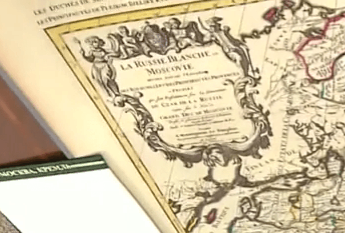
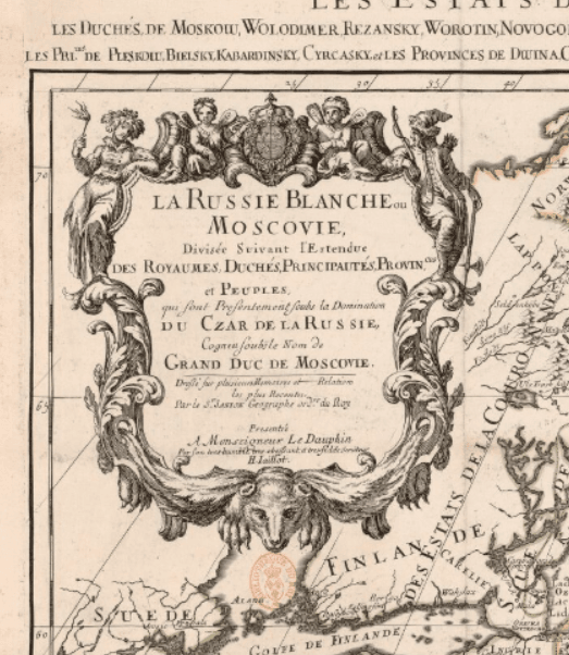
In one of the close-ups, you can even make out the text on the cartouche in the upper left corner: La Russie Blanche ou Moscovie (“White Rus' or Muscovy”).
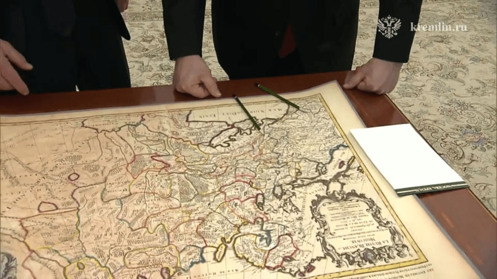
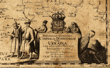
Original easy to find: this is one of the most famous maps of Eastern Europe from the 17th century. It was compiled for the heir to the French throne by cartographer Guillaume Sanson in 1674. A high-resolution digitized map is available on the French National Library website.
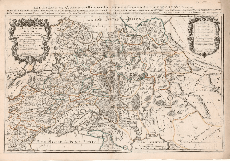
In the upper left corner is the same cartouche on which is written: “White Rus', or Muscovy, divided into kingdoms, duchies, principalities, provinces and nationalities, which are currently under the rule of the Tsar of Russia, known as the Grand Duke of Muscovy.”
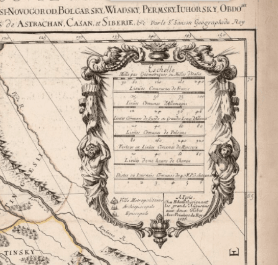
On the right cartouche is the scale in units adopted in Italy, Germany, France, England, Poland and Russia.
The name Ukraine is on the map, and in exactly the place where the Chairman of the Constitutional Court pointed.
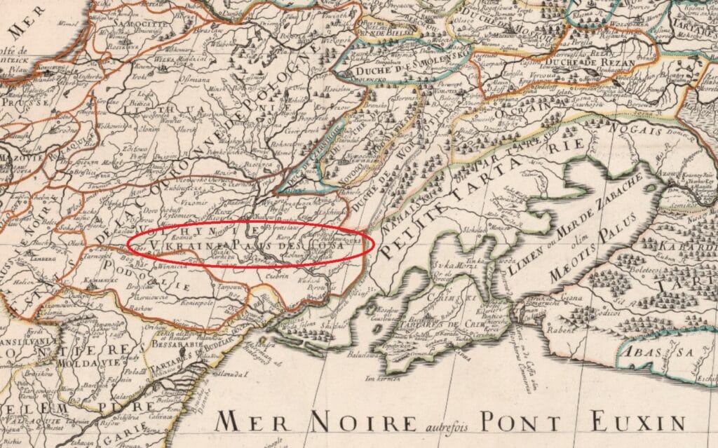
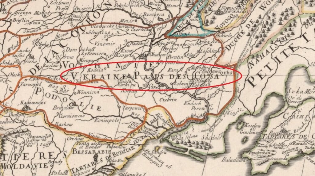
Perhaps Valery Zorkin was confused by the unusual font for him, when the Latin letter V is used instead of U. On the Sanson map it is written: Vkraine Pais des Cosaques. In modern French spelling it would look like Ukraine Pays des Cosaques, that is, “Ukraine, the country of the Cossacks.” It was this inscription that Zorkin interpreted as “the edge of Cossackia.”
The map, as Sanson wrote in the explanations, is divided not only into countries, but also into smaller territories. It indicates both Ukraine and the historical regions of the country, the names of which are still used today, for example Volhynie (Volyn) and Podolie (Podolie).
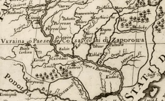
It is not difficult to find the name Ukraine on other maps of that era. In 1648, French engineer Guillaume Levasseur de Beauplan made up the first detailed description of Ukraine, indicating exactly this name on the cartouche in the lower left corner.
The work of the Italian Giacomo Cantelli is not too different from the Sansone map. On the map he made up in 1684, the same geographical area is listed as "Ukraine, or the Country of the Zaporozhye Cossacks".
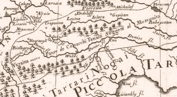
Moreover, on Cantelli’s map there is another land designated as Ukraine, along the Donets River (now Seversky Donets), from Belgorod to Voronezh. The Italian cartographer signed this area “Ukraine, or the Land of the Tanaitic (Don - Ed.) Cossacks, subordinate to Muscovy.”
Thus, on the map that Valery Zorkin showed to Vladimir Putin, Ukraine is present - in any case, the corresponding inscription on the map of 1674 is present. Apparently, the chairman of the Constitutional Court of Russia either did not find the inscription or could not read it correctly. The name Ukraine is also mentioned on other maps of the same period.
Cover photo: White Rus' or Muscovy. Guillaume Sanson, 1674. French National Library, Department of Maps and Plans

Not true
Read on the topic:
- Is it true that Ukrainian statehood was created by Vladimir Lenin?
- Is it true that medieval maps read “Here Be Dragons”?
- Is it true that the slogan “Glory to Ukraine!” was invented by the Banderaites?
If you find a spelling or grammatical error, please let us know by highlighting the error text and clicking Ctrl+Enter.