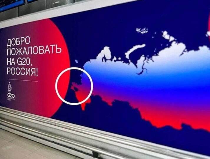
According to many Russian media, the organizers of the G20 welcomed the Russian delegation with a banner with a map of Russia, on which the DPR, LPR, Zaporizhzhya and Kherson regions were designated as part of the Russian territory. We checked whether the organizers of the summit really placed such a banner.
Many media wrote about the updated map of the Russian Federation, which allegedly appeared on a welcoming poster posted at Bali Airport (“RIA Novosti","Ren-TV","News","Komsomolskaya Truth","Kommersant"). Some publications do not specify who hung this banner, and other They write that it was the initiative of Indonesian leaders or organizers of the summit. According to URA.RUThus, "the organizers of the G20 summit in Indonesia recognized the expansion of Russia." Information also spread to Telegram, "VKontakte" Facebook, Twitter, discussions on Reddit and other sites.
September 30, 2022 Russian President Vladimir Putin Recognized Independence of the Kherson and Zaporizhzhya regions of Ukraine, and then signed Laws on the entry into Russia of four partially occupied Ukrainian regions: DPR, LPR, Kherson and Zaporizhzhya regions. The head of the UN condemned Russia's actions, Having saidthat they contradict international law and the charter of the organization. In addition, the UN General Assembly adopted a resolution that announced the annexation illegal. For the resolution voted 143 of 193 states - members of the UN, including Indonesia.
That is why the updated map of Russia, allegedly posted at Bali Airport at the G20 summit, caused the joy of many supporters of the annexation. The appearance of such a map was perceived by them as a sign of the official international recognition of these territories by part of Russia. Twitter user wrote: "It turns out that the world community still recognizes the accession of Kherson, Zaporozhye, the DPR and the LPR to Russia."
Nevertheless, this news with a photograph of a welcome banner raises a lot of questions. Firstly, we could not find a single photo of the same banner from other angles on the Internet. If the banner really sagged for some time at Bali Airport, where Flies The mass of Russian tourists, most likely, passengers would pay attention to the greeting in Russian and would share their photos on the network. Secondly, on the Internet there are no photos of such welcome banners for delegations of other countries. All billboards, banners and posters on G20 Decorated in a single style and depict The silhouettes of the Indonesian mountains. All inscriptions on official materials are made in English.
The digital image analysis showed several inconsistencies. The area of attached territories in the photo has a different sharpness and compression of the image, which is usually characteristic of photo collages.
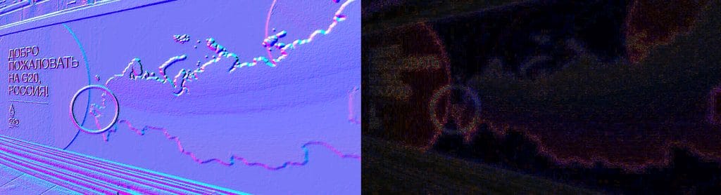
Back search By the image he issued a link to a similar map of Russia, laid out On VKontakte, the Typical Bryansk community on September 30, on the day Putin’s signing agreement on the accession of four territories. Most likely, this image served as the basis for the photo collage, where the author added the logo of the G20 summit and the text “Welcome to the G20, Russia!”.
So, we can conclude that the published photo of the banner with a high degree of probability is a fake. Most of the media who wrote about the banner refer to Telegram-fast The publications "Sputnik is near abroad" of November 16, 2022. This is the earliest mention that we found on the Internet. Therefore, most likely, it was the Satellite state publication, blocked in most West countries after the start of Russia's invasion of Ukraine in 2022, and became the original source of misinformation.
Image on the cover: Telegram

Fake
Read on the topic:
- Reuters. Most G20 Leaders Condemn Russia's War in Ukraine at Summit, Coome Take Different View
- Is it true that in the Spanish textbook they used a map of Ukraine, changed by the results of referenda?
- Is it true that the German television channel showed on its air a map of Ukraine, changed by the results of referenda?
If you find a spelling or grammatical error, please inform us of this, highlighting the text with an error and by pressing Ctrl+Enter.