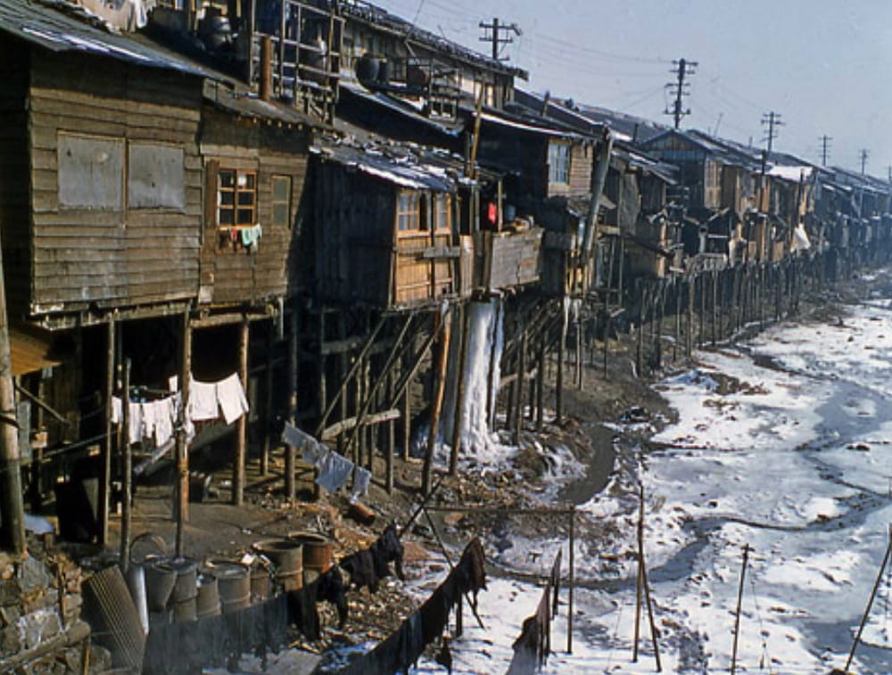
In April 2022, a photograph of a long line of huts on stilts went viral on social networks, the caption under which stated that this was an area not far from Moscow. We checked whether this is indeed the case.
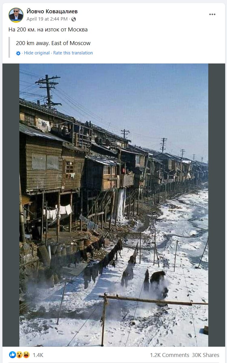
Gained the greatest popularity fast V Facebook, made by Bulgarian user Yovcho Kovasaliev on April 19 and captioned “200 km east of Moscow.” In the photograph we see a row of old wooden houses on stilts, as if ready to collapse. Below, on the edge of an icy pond, black laundry is drying on lines - another sign of poverty. This publication was shared by about 30,000 social network users as of April 29.
The description of the photo confused some readers, because wooden houses on stilts are more typical for Asia, although in Europe there are sometimes “huts on chicken legs” meet. However, the buildings that are included in the frame may well be extensions with solid foundations behind. Therefore, nothing can be ruled out in advance.
It’s easy to discover that another wave of popularity of this photo in the Russian-language segment of the Internet took place in the summer of 2019. The publications with her, although not as large, sold in large quantities Facebook, Twitter and on a number of others resources (including demotivators) was decorated with another signature: “Leninskoye village, Amur region, October 2018.” The problem is that within this villages There are no more or less noticeable bodies of water.
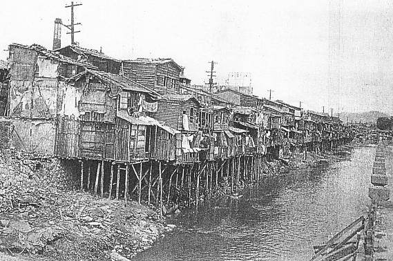
The first appearance of the photograph on the Internet was dated October 10, 2005, when it was published in the online community of amateur travel photographers. TrekEarth posted by a famous Turkish photographer Izzet Keribar. The photo is called “Slums on the Han River” and has the following description: “It’s hard to imagine what Seoul looked like in the post-war years. As I stated in another post, I served in Korea as an officer in a Turkish brigade in 1956-1957. Devastation and terrible poverty reigned there. These houses on the banks of the Han River reflect the enormity of poverty and suffering of the people. It was December 1956, a very cold month, the temperature dropped to -25 °C. Therefore, it is not surprising that water in the sewer system froze under one of the houses. The Han River is also frozen, look at the snow and drying clothes.”
Keribar is not entirely right: in the photo we see not the Hangan (the largest river in South Korea), but the Cheonggyecheon stream flowing into one of its tributaries. The modest waterway that crosses the center of Seoul from west to east became overgrown with shacks built by immigrants from impoverished provincial towns after the end of the Korean War (1950–1953).
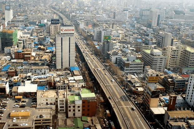
Soon, due to sewage being poured into the stream, Cheonggyecheon became a hotbed of unsanitary conditions, and only in the next decade did the city authorities decide to demolish the shacks and resettle their inhabitants. The stream was hidden in a concrete pipe, and above it erected double-decker highway.
By the 2000s, when the environmental damage caused to the city center by the expressway became obvious, authorities reconsidered your decision and released Cheonggyecheon into the wild. Today it is one of the main attractions of Seoul - an 11-kilometer recreation area with parks and cozy bridges.
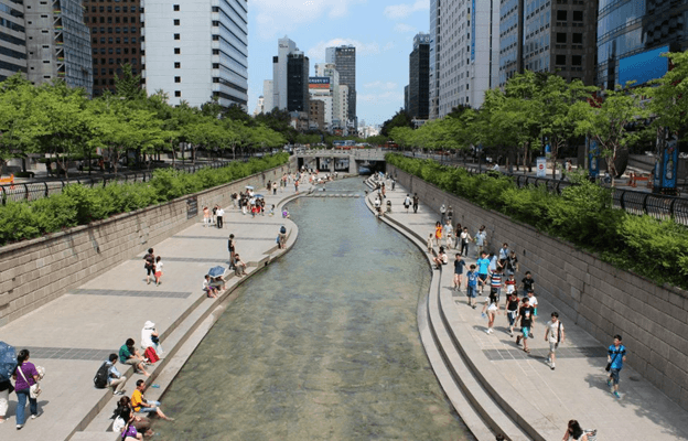
In this picturesque embankment it is difficult to recognize the slums of old Seoul, but it was here, and not in the Amur region and especially not in the vicinity of Moscow, that a photograph popular on social networks was taken many decades ago.

Not true
If you find a spelling or grammatical error, please let us know by highlighting the error text and clicking Ctrl+Enter.


